Accounting for carbon
Managing forests to store carbon is a key approach to lessening the effects of human-induced climate change. Forests sequester more carbon annually than any other land use and have the potential to offset carbon released through energy production, transportation, manufacturing, agriculture, and forestry.
However, we can’t manage what we can’t measure. So how do we measure, with certainty, the carbon stored in our forest lands? Chad Babock, PhD, assistant professor in the Department of Forest Resources, and research associate and master’s student Ethan Emick, are taking inventory of carbon stocks at the Cloquet Forestry Center in northeastern Minnesota using a fusion of forest measurements and remote sensing data.
The carbon cycle — a system where carbon in various chemical forms flows from land and water through the atmosphere and back — is fundamental to life on earth, explains Babcock.
“Forests play an important role in this cycle by sequestering carbon from the atmosphere, and releasing carbon through decay and disturbances, such as timber harvests and fire,” he said. “Forests are the largest terrestrial carbon sink on the planet, and managing them to store carbon can be an effective way to offset atmospheric CO2 emissions.”
Forest carbon has been commoditized through the creation of forest carbon markets. However, measuring the amount of carbon stored can be prohibitively expensive, especially for small forest landowners. Babcock and Emick are working on a new approach to spatially predict and map forest carbon to help reduce the costs of monitoring.
“There are many ways to map forest carbon with remote sensing data and field observations,” said Emick. “What’s missing is an ability to characterize uncertainty in a way that’s useful for trading. To trade on the market, forest carbon must be estimated with statistical rigor, meaning that any estimates of carbon storage must be statistically defensible.”
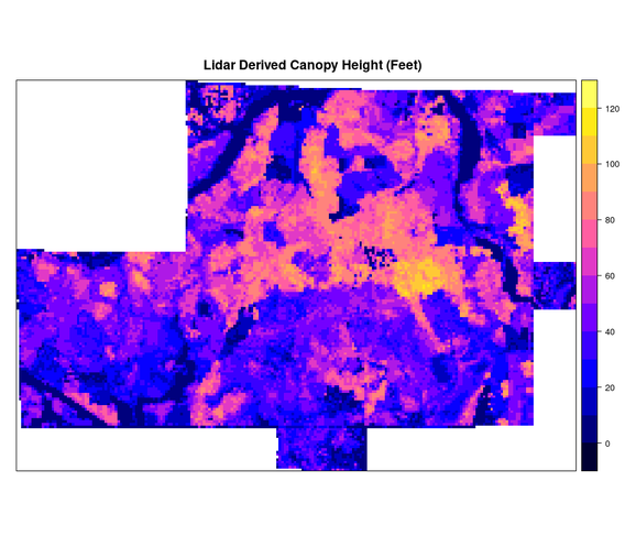
The CFANS team’s approach aims to address this issue using light detection and ranging (lidar) data from Minnesota and Bayesian hierarchical spatial modelling (a statistical model written in multiple levels). The spatial model relates the CFC field plot observations and the lidar variables, explains Emick, providing excellent predictions and, more importantly, confidence intervals that accurately describe how certain they are in their predictions. Learn more by visiting the Cloquet Forestry Center's website.


